Saturday, November 11, 2006 

the long-awaited project

Well, I've been talking about it all term. This project has consumed so much of my time, although it's been really fun to work on, and it has finally reached the state (and the point of the term) when it is ready to be unveilled. As I mentioned in my last post, this will all eventually be on a website, but for now, here it is...

The links should all download as .kmz files, which can be opened in Google Earth, which is available for free on Mac, PC, and Linux. Make sure the terrain is turned on (in the check boxes at the bottom), or the models might be floating far above a flat earth. As a mini-explanation of their creation, the models were all built (by me!) in Google SketchUp, a very simple free program that I have been learning how to use this term. The projects the models link to were all created by Joe and I, using digital media and various computer programs to edit and put it together. They will all eventually have some sort of accompanying text explaining why we chose to represent them in the way we did, but for now, here are the files, in approximate order of creation:

New York City:

I-House

El Puerto

Bronx Zoo

NYC Subway

Sambuca

London:

The Eagle and Child

Buckingham Palace

Millennium Bridge

Shikara

ISH

Amsterdam:

Leidseplein

Haarlem Windmill

Apple Inn Hotel

Grocery Store

Waag
(including links "circling the Waag" from projects done by whole class)

Friday, November 10, 2006 

evolution of mapping

Well, things here are winding down. There is so much I want to see in Berlin, but not enough time to do all that and finish up work. Things are finally coming together though, and Joe and I are getting close to having some sort of presentation ready for the project we have been working on all term (and will continue to work on after this trip is over). We are in the process of setting up a website to house the project, and the other night we were writing some content for that page. The little background paragraph we were working on introduced some cool ideas, and the next thing we knew, we had a mini-essay on the history of mapping. It sets the stage for our project, introducing the concepts that really are the foundation of this sort of mapping exploration. So, for anybody who is interested, here it is, in its current form:

The Evolution of Maps as a Means of Representing Space

Maps, as a tool used in representing place, have been evolving throughout history according to a pattern reflecting both their purposes and the technologies that constrain them. The evolution of maps to this point can be characterized as a continuing process of more accurately representing physical places and their relationships in a way that precisely mirrors their visual appearance. With the digital age, technology has rapidly pushed visual precision to new levels, to the extent that it is appearing that accuracy, at least as perceived through the sense of sight, is beginning to approach its limits. As the traditional mapping sensibility is exhausted, the desire for accurate portrayal of place will naturally extend to the other senses, which can convey place in ways that the sense of sight has never been able to. Sound, emotions, feelings, and a myriad of other forms of perception will be incorporated into maps of the future through artistic means to better embody the places we encounter. As technology makes it increasingly feasible, the desire for “true” portrayals of space will lead people to art because art has, and always will be, the most appropriate means of expressing how something is in all its complexity.

The history of maps is a narrative that is intimately linked to mankind’s ability to gather and disseminate information. In the past, peo
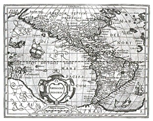
ple relied on word-of-mouth stories of far-off places. As the knowledge base expanded and humans developed needs that required finding specific locations that involved complex directions, it became necessary to record one’s conception of space in a more permanent, visually-depictive manner. This is where mapping emerged as a key element of culture. Originally hand-drawn, and more recently, thanks to modern-day technology, cheaply mass-printed, maps made accessible a representation of the world in a portable form.

In this age of computers, information about place has made the jump to the Internet, and mapping has followed as well. Now, huge archives of maps may be accessed, searched, and manipulated from the convenience of a comfy armchair, at no cost to the user. Through online interfaces, such as Google Maps, Yahoo Maps, and Mapquest, a user need only type in departure and destination points, and a map appears with a colored line tracing the path between the locations. Places are connected in a web more tightly than ever, and mapping seems to have reached a new level of accessibility.

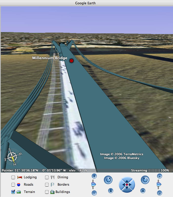
In the ever-expanding Internet full of cutthroat competitors, digital mapmakers needed to find a new direction in which to improve, and accuracy became a focus. In 2005, Google released a new mapping platform, Google Earth. This program goes beyond providing a digital version of paper maps by showing the globe as a fabric of full-color satellite images. Users can see the whole world, zooming in on areas of interest, rotating the terrain, and seeing in surprising detail the homes, cars, people, and trees on streets they have previously known only as names on a map.

Google went a step further in visually representing objects in space with the introduction of SketchUp – 3-D model-making software that allows users to build and import buildings into Google Earth – a step that puts mapmaking, or at least a facet of it, into the hands of the map user. With its photo-accurate, satellite capabilities and its robust communal network, Google Earth has become today’s most digitally advanced, public map. While there still is room for improvement in the area of magnification, the threshold of true, visual representations of physical space now appears to be within reach: a 3-D, perhaps live, Google Earth with a finer zoom.

Even if one were to follow the platform’s precision-progression along its seemingly asymptotic advance to infinity, Google Earth would still never be able to adequately represent real places because it can only do so through one sense: the sense of sight. There would still be room for mapping to grow, even in the face of visually-depictive perfection, because the world we live in is experienced through all the senses, not just sight.

Emotion. Sound. Feeling. All of these will be incorporated into maps of the future as people endeavor to better encapsulate the complexity of place. It seems only natural that art will be the form of expressing place in all its intricacies because the reality of a place is far too complex and subjective for anything but art to be able to adequately describe it. We are keenly aware of the fact that our experiences and perceptions are subjective, that they are unique and personally meaningful expressions of reality. Thus, if people desire to accurately represent their significant places in a map context for other people to experience and view in relationship to the surrounding geography, the Google Earth of tomorrow will be the avenue of creative self-expression by which they can best do so. This is the focus of our project: we are exploring the possibilities of the Google Earth medium as an artistic platform for representing place.

Monday, November 06, 2006 

urban screens, left and right

Our first two organized talks here in Berlin were on a very similar topic: the new urban screens that are springing up in cities all over the world. And, well, I'm not too sure yet what to think of them, but I have some ideas. Before I get into all of that, I'll give a quick overview of our speakers and their talks that prompted my thinking.

The first speaker was really impressive, probably because he is actually involved in conceptualizing and designing projects for the urban landscape, a few of which have been big urban screens. Jan Elder of realities:united talked us through some of the projects he and his brother have orchestrated, and they are really amazing. Their most famous is probably the BIX skin they put on the Kunsthaus Graz, a large center built in Austria as part of some European fair thing (please excuse my ignorance and lack of time to look this all up, I'm sure it's on the website above). It's made up of all these flourescent tubes, so it's way bigger and way cheaper than any super high-tech LED screen could be. And the best part is that it just plays artistic pieces, instead of being full of commercial advertising. The other really neat piece he described to us doesn't actually exist yet, but it involves really tall metal poles that can sway in the wind, as a result of some amazing design. Seriously, how cool is that?

Our second speaker, Mirjam Struppek, has done an incredible amount of research and documentation of urban screens. She shared with us a bunch of projects, many of them interactive, that have taken place over the past few years. She called to our attention the different uses for urban screens, whether they be commercial, artistic, informative, or some combination. They are becoming a common element of the city landscape, but we need to also look at how city culture is shaping and being shaped by these screens.

As commercial screens and advertisements, the things drive me crazy. They make a place feel so impersonal, and they draw attention away from the architecture and other things I actually want to be seeing. I don't like that advertisements are invading so many parts of daily life, and I feel like there need to be places to get away from them. However, I don't mind billboards as much. It's just something about the LED screen, the color, and the motion that draws my attention, as advertisers want, and presents me with advertising I'd rather avoid. Then there is this gray area of screens that were built not necessarily to sell advertising space, but just to make the building famous by being big and flashy. For example, the SPOTS facade realities:united built on an office building on Potsdamer Platz in Berlin was created because the building wanted to draw attention to itself and sell its unused office space. It has succeeded, because most people who travel through the area now notice this huge display of flashing flourescent lights. So, although it plays patterns and artistic pieces instead of advertising, it is still a form of advertising, as any urban screen will almost inevitably be. Then we come to the screens that are art for art's sake, or interactive projects designed to provide people with information or entertainment. Those might have some merit, and they are interesting ways of capturing the attention of people and making them think about things they never may have before. But, the things just bother me because of how flashy they are. They demand attention, and I don't like being told in such a blatant way what elements around me should be looked at.

On Saturday we went on a bus tour of Berlin, or at least the most historically significant parts of it. I won't go into too much detail, but I will say that it was a pretty eye-opening experience to see and hear about what Berlin was like in such recent history. As part of the tour, we stopped by the new Holocaust Memorial, opened in 2005 as a "monument to the murdered Jews of Europe." It is a sprawling area of large gray concrete slabs arranged in a grid. The idea, as it was described to us, is that as you wander the rows, people pass in and out of your vision, but you never really know if and when you will see them again. Pretty powerful stuff. I think the part that hit me hardest was that as I was coming out of it, I came across trees planted where concrete slabs should have been. It was like they were the ones who survived, surrounded on all sides by the graves and monuments of their loved ones. It is really a beautifully designed piece of architecture.